
Mapa topográfico Grundy Center
Mapa interactivo
Haga clic en el mapa para ver la altitud.
Acerca de este mapa
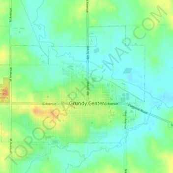
Nombre: Mapa topográfico Grundy Center, altitud, relieve.
Lugar: Grundy Center, Grundy County, Iowa, United States (42.35343 -92.79754 42.37611 -92.75381)
Altitud media: 306 m
Altitud mínima: 293 m
Altitud máxima: 327 m
Otros mapas topográficos
Haga clic en un mapa para ver su topografía, su altitud y su relieve.
Dike
United States > Iowa > Grundy County
Dike, Grundy County, Iowa, United States
Altitud media: 291 m
Conrad
United States > Iowa > Grundy County
Conrad, Grundy County, Iowa, 50621, United States
Altitud media: 313 m
Beaman
United States > Iowa > Grundy County
Beaman, Grundy County, Iowa, United States
Altitud media: 309 m
Wellsburg
United States > Iowa > Grundy County
Wellsburg, Grundy County, Iowa, United States
Altitud media: 327 m
Reinbeck
United States > Iowa > Grundy County
Reinbeck, Grundy County, Iowa, 50669, United States
Altitud media: 290 m
Holland
United States > Iowa > Grundy County
Holland, Grundy County, Iowa, United States
Altitud media: 310 m
Stout
United States > Iowa > Grundy County
Stout, Grundy County, Iowa, 50673, United States
Altitud media: 309 m
Morrison
United States > Iowa > Grundy County
Morrison, Grundy County, Iowa, 50657, United States
Altitud media: 295 m