
Gracias por apoyar a este sitio ❤️
Haz una donación
Haz una donación
Mapa topográfico Gokyo
Haga clic en el mapa para ver la altitud.
Gracias por apoyar a este sitio ❤️
Haz una donación
Haz una donación
Gokyo
Located at an elevation of 4,750 m (15,584 ft), the village is one of the highest settlements in Nepal and in the world. Almost all the buildings are guest houses for trekkers. The people who live in the village leave during the winter and move to other (lower) villages, or Kathmandu.
Gracias por apoyar a este sitio ❤️
Haz una donación
Haz una donación
Acerca de este mapa
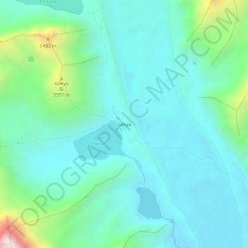
Nombre: Mapa topográfico Gokyo, altitud, relieve.
Altitud media: 4.919 m
Altitud mínima: 4.676 m
Altitud máxima: 5.926 m
Gracias por apoyar a este sitio ❤️
Haz una donación
Haz una donación
Otros mapas topográficos
Haga clic en un mapa para ver su topografía, su altitud y su relieve.