
Mapa topográfico Great Sand Dunes National Park
Mapa interactivo
Haga clic en el mapa para ver la altitud.
Acerca de este mapa
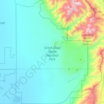
Nombre: Mapa topográfico Great Sand Dunes National Park, altitud, relieve.
Altitud media: 2.616 m
Altitud mínima: 2.292 m
Altitud máxima: 4.100 m
In 1848, John C. Frémont was hired to find a railroad route from St. Louis to California. He crossed the Sangre de Cristos into the San Luis Valley in winter, courting disaster but proving that a winter crossing of this range was possible. He was followed in 1853 by Captain John Gunnison of the Corps of Topographical Engineers. Gunnison's party crossed the dune field on horseback.
Otros mapas topográficos
Haga clic en un mapa para ver su topografía, su altitud y su relieve.
Center
United States > Colorado > Saguache County
Center, Saguache County, Colorado, 81125, United States
Altitud media: 2.331 m
Sargents
United States > Colorado > Saguache County
Sargents, Saguache County, Colorado, United States
Altitud media: 2.676 m
Poncha Pass
United States > Colorado > Saguache County
Poncha Pass, Saguache County, Colorado, United States
Altitud media: 2.748 m
Crestone
United States > Colorado > Saguache County
Crestone, Saguache County, Colorado, United States
Altitud media: 2.444 m
Sargents Mesa
United States > Colorado > Saguache County
Sargents Mesa, Saguache County, Colorado, United States
Altitud media: 3.464 m