
Mapa topográfico Odell
Mapa interactivo
Haga clic en el mapa para ver la altitud.
Acerca de este mapa
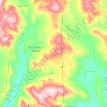
Nombre: Mapa topográfico Odell, altitud, relieve.
Lugar: Odell, Coös County, New Hampshire, United States (44.65996 -71.44437 44.79573 -71.32428)
Altitud media: 673 m
Altitud mínima: 368 m
Altitud máxima: 1.114 m
A substantial portion of the state-owned Nash Stream Forest lies within the township. There are three mountains, each having elevations above 3,000 feet (910 m): Muise Mountain, Whitcomb Mountain and Long Mountain, whose two summits are the two highest points in Odell, at 3,661 feet (1,116 m) above sea level each. There are only a few rough roads and no highways here.