
Gracias por apoyar a este sitio ❤️
Haz una donación
Haz una donación
Mapa topográfico Saltville
Haga clic en el mapa para ver la altitud.
Gracias por apoyar a este sitio ❤️
Haz una donación
Haz una donación
Acerca de este mapa
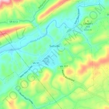
Nombre: Mapa topográfico Saltville, altitud, relieve.
Lugar: Saltville, Smyth County, Virginia, 24370, United States (36.84830 -81.80096 36.90559 -81.73622)
Altitud media: 617 m
Altitud mínima: 507 m
Altitud máxima: 870 m
Gracias por apoyar a este sitio ❤️
Haz una donación
Haz una donación
Otros mapas topográficos
Haga clic en un mapa para ver su topografía, su altitud y su relieve.
Mount Rogers
United States > Virginia > Smyth County
Mount Rogers is the highest natural point in Virginia, United States, with a summit elevation of 5,729 ft (1,746 m) above mean sea level. The summit straddles the border of Grayson and Smyth Counties, Virginia, about 6.45 mi (10.38 km) WSW of Troutdale, Virginia. Most of the mountain is contained within the…
Altitud media: 1.507 m