
Mapa topográfico Eastsound
Mapa interactivo
Haga clic en el mapa para ver la altitud.
Acerca de este mapa
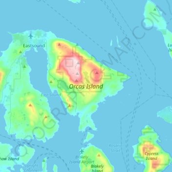
Nombre: Mapa topográfico Eastsound, altitud, relieve.
Altitud media: 59 m
Altitud mínima: -1 m
Altitud máxima: 723 m
Mount Constitution (elevation 2,409 feet (734 meters) is the highest point in the San Juan islands. The mountain is part of Moran State Park, the largest public recreation area in the San Juan Islands, and the largest State Park in Washington. Moran State Park encompasses over 5,000 acres (2,000 hectares) of woodland and has several lakes, including Cascade Lake, Mountain Lake, Summit Lake, and Twin Lakes, and numerous waterfalls.
Otros mapas topográficos
Haga clic en un mapa para ver su topografía, su altitud y su relieve.
San Juan Islands National Wildlife Refuge
United States > Washington > San Juan County
San Juan Islands National Wildlife Refuge, San Juan County, Washington, United States
Altitud media: 24 m
O'Neal Island
United States > Washington > San Juan County
O'Neal Island, San Juan County, Washington, United States
Altitud media: 18 m
Friday Harbor
United States > Washington > San Juan County
Friday Harbor, San Juan County, Washington, 98250, United States
Altitud media: 28 m
Ben Nevis
United States > Washington > San Juan County
Ben Nevis, San Juan County, Washington, 98286, United States
Altitud media: 49 m
Spencer Lake
United States > Washington > San Juan County > Thatcher
Spencer Lake, Thatcher, San Juan County, Washington, United States
Altitud media: 150 m
Eastsound
United States > Washington > San Juan County
Eastsound, San Juan County, Washington, 98245, United States
Altitud media: 74 m