
Gracias por apoyar a este sitio ❤️
Haz una donación
Haz una donación
Mapa topográfico Alsea
Haga clic en el mapa para ver la altitud.
Gracias por apoyar a este sitio ❤️
Haz una donación
Haz una donación
Acerca de este mapa
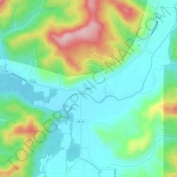
Nombre: Mapa topográfico Alsea, altitud, relieve.
Lugar: Alsea, Benton County, Oregon, United States (44.36151 -123.61649 44.40151 -123.57649)
Altitud media: 154 m
Altitud mínima: 74 m
Altitud máxima: 343 m
Gracias por apoyar a este sitio ❤️
Haz una donación
Haz una donación
Otros mapas topográficos
Haga clic en un mapa para ver su topografía, su altitud y su relieve.
Corvallis
United States > Oregon > Benton County
Corvallis is at an elevation of 235 feet (72 m) above sea level. Situated midway in the Willamette Valley, in terms of driving distances, Corvallis is about 46 miles (74 km) east of Newport and the Oregon Coast, 85 miles (137 km) south of Portland, 30 miles (48 km) south of the state capital, Salem, 10 miles…
Altitud media: 81 m
Gracias por apoyar a este sitio ❤️
Haz una donación
Haz una donación