
Haz una donación
Mapa topográfico Harrah
Haga clic en el mapa para ver la altitud.
Haz una donación
Harrah
Harrah is a small city in Oklahoma with a total land area of 11.9 square miles (31 km2), all land. The city's elevation is 925 feet (282 m) above sea level. It lies partly in the Great Plains near the geographical center of the 48 contiguous states in the United States. It lies between the larger cities of Oklahoma City to the west and Shawnee, to the east, in Oklahoma County.
Haz una donación
Acerca de este mapa
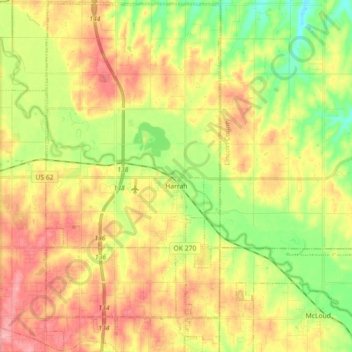
Nombre: Mapa topográfico Harrah, altitud, relieve.
Lugar: Harrah, Oklahoma County, Oklahoma, United States (35.42050 -97.23034 35.56635 -97.14076)
Altitud media: 342 m
Altitud mínima: 294 m
Altitud máxima: 389 m
Haz una donación
Otros mapas topográficos
Haga clic en un mapa para ver su topografía, su altitud y su relieve.
Newalla
United States > Oklahoma > Oklahoma County > Oklahoma City
Newalla, with a current elevation of 1,148 feet, is located within the Eastern bounds of Oklahoma County and appears on the Harrah, Oklahoma U.S. Geological Survey Map due to their proximity. Newalla is a geographic area which spans unincorporated Oklahoma County and unincorporated Cleveland County (also…
Altitud media: 343 m
Haz una donación
Lightning Creek Holding Pond B Dam
United States > Oklahoma > Oklahoma County > Oklahoma City
Altitud media: 386 m
Haz una donación