
Haz una donación
Mapa topográfico Dharamshala
Haga clic en el mapa para ver la altitud.
Haz una donación
Dharamshala
The town is located in the Kangra Valley, in the shadow of the Dhauladhar range of the Himalayas at an altitude of 1,457 metres (4,780 ft). References to Dharamshala and its surrounding areas are found in ancient Hindu scriptures such as Rig Veda and Mahabharata. The region was under Mughal influence before it was captured by the Sikh empire in 1785. The East India Company captured the region for the British following the First Anglo-Sikh War of 1846, from when it became part of the British Indian province of the Punjab. Post Indian Independence in 1947, it remained as a small hill station. In 1960, the Central Tibetan Administration was moved to Dharamshala when the 14th Dalai Lama Tenzin Gyatso established the Tibetan administration-in-exile after he had to flee Tibet.
Haz una donación
Acerca de este mapa
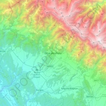
Nombre: Mapa topográfico Dharamshala, altitud, relieve.
Lugar: Dharamshala, Kangra, Himachal Pradesh, 176200, India (32.05430 76.15967 32.37430 76.47967)
Altitud media: 1.781 m
Altitud mínima: 485 m
Altitud máxima: 4.909 m
Haz una donación
Otros mapas topográficos
Haga clic en un mapa para ver su topografía, su altitud y su relieve.