
Gracias por apoyar a este sitio ❤️
Haz una donación
Haz una donación
Mapa topográfico Belvezet
Haga clic en el mapa para ver la altitud.
Gracias por apoyar a este sitio ❤️
Haz una donación
Haz una donación
Acerca de este mapa
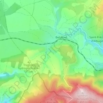
Nombre: Mapa topográfico Belvezet, altitud, relieve.
Altitud media: 1.251 m
Altitud mínima: 1.121 m
Altitud máxima: 1.493 m
Gracias por apoyar a este sitio ❤️
Haz una donación
Haz una donación
Otros mapas topográficos
Haga clic en un mapa para ver su topografía, su altitud y su relieve.
Gracias por apoyar a este sitio ❤️
Haz una donación
Haz una donación
Gracias por apoyar a este sitio ❤️
Haz una donación
Haz una donación
Ruisseau de Coufoulens
France > Occitanie > Lozère > Mont Lozère et Goulet > Saint-Frézal-d'Albuges > La Peyre
Altitud media: 1.215 m
Gracias por apoyar a este sitio ❤️
Haz una donación
Haz una donación