
Haz una donación
Mapa topográfico Dodge City
Haga clic en el mapa para ver la altitud.
Haz una donación
Dodge City
Dodge City is located at 37°45′35″N 100°1′6″W / 37.75972°N 100.01833°W / 37.75972; -100.01833 (37.759671, −100.018212) at an elevation of 2,493 ft (760 m). It lies on the Arkansas River in the High Plains region of the Great Plains. The city sits above one of the world's largest underground water systems, the Ogallala Aquifer, and is 25 miles (40 km) from the eastern edge of the Hugoton Natural Gas Area. Located at the intersection of U. S. Routes 50, 56 and 283 in southwestern Kansas, Dodge City is 151 mi (243 km) west of Wichita, 199 mi (320 km) northeast of Amarillo, and 301 mi (484 km) southeast of Denver.
Haz una donación
Acerca de este mapa
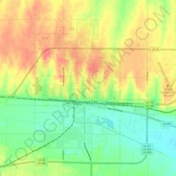
Nombre: Mapa topográfico Dodge City, altitud, relieve.
Lugar: Dodge City, Ford County, Kansas, 67801, United States (37.72492 -100.05593 37.79469 -99.94277)
Altitud media: 777 m
Altitud mínima: 747 m
Altitud máxima: 809 m
Haz una donación
Otros mapas topográficos
Haga clic en un mapa para ver su topografía, su altitud y su relieve.