
Haz una donación
Mapa topográfico Aspet
Haga clic en el mapa para ver la altitud.
Haz una donación
Aspet
Located in the middle of the Pyrenees mountain chain, within the ancient region of Comminges, Aspet sits 15 km south to Saint-Gaudens and at the foot of the Cagire (1,912 metres (6,273 ft) in Altitude).
Haz una donación
Acerca de este mapa
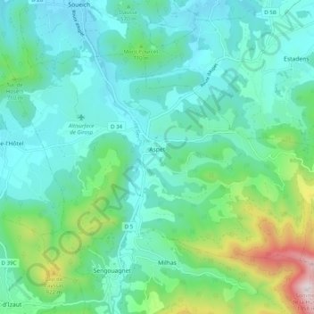
Nombre: Mapa topográfico Aspet, altitud, relieve.
Altitud media: 583 m
Altitud mínima: 385 m
Altitud máxima: 1.340 m
Haz una donación
Otros mapas topográficos
Haga clic en un mapa para ver su topografía, su altitud y su relieve.
Haz una donación
Toulouse
France > Occitania > Haute-Garonne > Toulouse
The first half of the 14th century was a prosperous period, despite the dismemberment in 1317 of the very large bishopric of Toulouse (which lost two thirds of its area and a large part of its income, a loss only partially compensated by its elevation to the rank of archbishopric), and the episode of the…
Altitud media: 173 m