
Haz una donación
Mapa topográfico Jenson
Haga clic en el mapa para ver la altitud.
Haz una donación
Acerca de este mapa
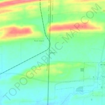
Nombre: Mapa topográfico Jenson, altitud, relieve.
Lugar: Jenson, Sebastian County, Arkansas, United States (35.17671 -94.45706 35.21671 -94.41706)
Altitud media: 177 m
Altitud mínima: 146 m
Altitud máxima: 240 m
Haz una donación
Otros mapas topográficos
Haga clic en un mapa para ver su topografía, su altitud y su relieve.
Fort Smith
United States > Arkansas > Sebastian County
The United States acquired this territory and large areas west of the Mississippi River from France in the Louisiana Purchase (1803). Soon after, the government sent the Pike Expedition (1806) to explore the areas along the Arkansas River. The US founded Fort Smith in 1817 as a military post. It was named…
Altitud media: 140 m
Fort Smith
United States > Arkansas > Sebastian County
The United States acquired the territory and large areas west of the Mississippi River from France in the Louisiana Purchase (1803). Soon after, the government sent the Pike Expedition (1806) to explore the areas along the Arkansas River. The US founded Fort Smith in 1817 as a military post. It was named after…
Altitud media: 140 m
Haz una donación