
Haz una donación
Mapa topográfico Paonta Sahib
Haga clic en el mapa para ver la altitud.
Haz una donación
Paonta Sahib
Paonta Sahib is located at 30°26′17″N 77°37′26″E / 30.438°N 77.624°E / 30.438; 77.624. It has an average elevation of 389 metres (1,276 feet). It is on the bank of the river Yamuna, the river being the boundary between the states of Himachal Pradesh and Uttarakhand. It is situated near the towns of Nahan in Himachal Pradesh, Yamunanagar in Haryana, Saharanpur in Western Uttar Pradesh and Dehradun in Uttarakhand. It is on the western extreme of the Doon Valley, which is at a distance of about 44 km from Dehradun. Kalesar National Park is 12 km from Paonta Sahib. Colonel Sher Jung National Park is around 7 km from the main town. Some luxury hotels to stay in Paonta Sahib are Hotel Guru Surbhi, Hotel Yamuna, and Hotel Paonta Valley.
Haz una donación
Acerca de este mapa
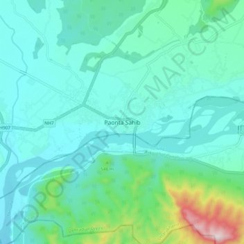
Nombre: Mapa topográfico Paonta Sahib, altitud, relieve.
Altitud media: 443 m
Altitud mínima: 356 m
Altitud máxima: 864 m
Haz una donación