
Haz una donación
Mapa topográfico Exeter Township
Haga clic en el mapa para ver la altitud.
Haz una donación
Exeter Township
According to the U.S. Census Bureau, the township has a total area of 24.6 square miles (64 km2), of which 24.4 square miles (63 km2) is land and 0.2 square miles (0.52 km2) (0.77%) is water. It is drained by the Schuylkill River, which forms its natural southern boundary. While areas closer to the river are low-lying, the northwestern area of the township is in the South Mountains and exceeds 250 metres (820 feet) at its highest elevation.
Haz una donación
Acerca de este mapa
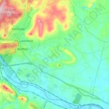
Nombre: Mapa topográfico Exeter Township, altitud, relieve.
Altitud media: 113 m
Altitud mínima: 44 m
Altitud máxima: 327 m
Haz una donación
Otros mapas topográficos
Haga clic en un mapa para ver su topografía, su altitud y su relieve.
Haz una donación
Haz una donación
Maple Grove Park
United States > Pennsylvania > Berks County > Brecknock Township
Altitud media: 198 m
Haz una donación
Tulpehocken Creek
United States > Pennsylvania > Berks County > Penn Township > Pleasant Valley
Altitud media: 111 m
Haz una donación
Haz una donación
Haz una donación
Haz una donación
Spring Ridge
United States > Pennsylvania > Berks County > Spring Township > Spring Ridge
Altitud media: 98 m
Blue Marsh Bernville Levee
United States > Pennsylvania > Berks County > Bernville
Altitud media: 111 m
Haz una donación