
Mapa topográfico Hadamar
Mapa interactivo
Haga clic en el mapa para ver la altitud.
Hadamar
Hadamar lies 7 km north of Limburg between Cologne and Frankfurt am Main on the southern edge of the Westerwald at elevations from 120 to 390 m above sea level.
Acerca de este mapa
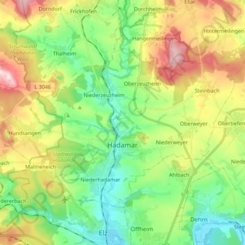
Nombre: Mapa topográfico Hadamar, altitud, relieve.
Lugar: Hadamar, Landkreis Limburg-Weilburg, Hesse, 65589, Germany (50.42390 7.99434 50.49321 8.15132)
Altitud media: 215 m
Altitud mínima: 110 m
Altitud máxima: 396 m
Otros mapas topográficos
Haga clic en un mapa para ver su topografía, su altitud y su relieve.