
Haz una donación
Mapa topográfico Queens
Haga clic en el mapa para ver la altitud.
Haz una donación
Queens
Many of the village street grids of Queens had only worded names, some were numbered according to local numbering schemes, and some had a mix of words and numbers. In the early 1920s, a "Philadelphia Plan" was instituted to overlay one numbered system upon the whole borough. The Topographical Bureau, Borough of Queens, worked out the details. Subway stations were only partly renamed, and some, including those along the IRT Flushing Line (7 and <7> trains), now share dual names after the original street names. In 2012, some numbered streets in the Douglaston Hill Historic District were renamed to their original names, with 43rd Avenue becoming Pine Street.
Haz una donación
Acerca de este mapa
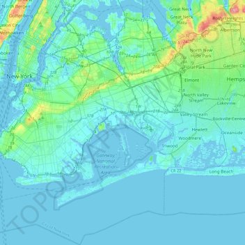
Nombre: Mapa topográfico Queens, altitud, relieve.
Lugar: Queens, Queens County, New York, United States (40.49212 -74.04378 40.81214 -73.70023)
Altitud media: 11 m
Altitud mínima: -8 m
Altitud máxima: 109 m
Haz una donación
Otros mapas topográficos
Haga clic en un mapa para ver su topografía, su altitud y su relieve.