
Gracias por apoyar a este sitio ❤️
Haz una donación
Haz una donación
Mapa topográfico Linglestown
Haga clic en el mapa para ver la altitud.
Gracias por apoyar a este sitio ❤️
Haz una donación
Haz una donación
Linglestown
The highest elevation is 995 feet (303 m) on the south slope of Blue Mountain, along Blue Mountain Parkway north of the center of town. Pennsylvania Route 39 (Linglestown Road) passes east-to-west through the village, leading east 3.5 miles (5.6 km) to Exit 77 on Interstate 81 and west 5 miles (8 km) to Highway 22-322 at the north end of Harrisburg.
Gracias por apoyar a este sitio ❤️
Haz una donación
Haz una donación
Acerca de este mapa
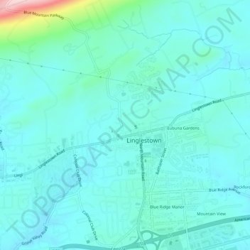
Nombre: Mapa topográfico Linglestown, altitud, relieve.
Altitud media: 161 m
Altitud mínima: 124 m
Altitud máxima: 376 m
Gracias por apoyar a este sitio ❤️
Haz una donación
Haz una donación