
Mapa topográfico East Village
Mapa interactivo
Haga clic en el mapa para ver la altitud.
Acerca de este mapa
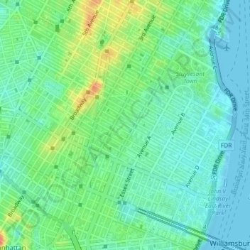
Nombre: Mapa topográfico East Village, altitud, relieve.
Altitud media: 15 m
Altitud mínima: -1 m
Altitud máxima: 46 m
Otros mapas topográficos
Haga clic en un mapa para ver su topografía, su altitud y su relieve.
Meatpacking District
USA > New York > New York City
Meatpacking District, Manhattan, Manhattan Community Board 2, New York County, New York City, New York, 100014, USA
Altitud media: 9 m
East River
USA > New York > New York City
East River, New York County, New York City, New York, 10044, USA
Altitud media: 15 m
Governors Island
USA > New York > New York City
Governors Island, Manhattan Community Board 1, New York County, New York City, New York, USA
Altitud media: 1 m
Chelsea
USA > New York > New York City
Chelsea, Manhattan, Manhattan Community Board 4, New York County, New York City, New York, USA
Altitud media: 13 m
SoHo
USA > New York > New York City
SoHo, Manhattan, Manhattan Community Board 2, New York County, New York City, New York, 10012, USA
Altitud media: 15 m
Barren Island
USA > New York > New York City
Barren Island, Kings County, New York City, New York, 11697, USA
Altitud media: 16 m