
Mapa topográfico Flower Hill
Mapa interactivo
Haga clic en el mapa para ver la altitud.
Acerca de este mapa
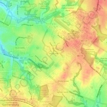
Nombre: Mapa topográfico Flower Hill, altitud, relieve.
Altitud media: 147 m
Altitud mínima: 110 m
Altitud máxima: 176 m
Otros mapas topográficos
Haga clic en un mapa para ver su topografía, su altitud y su relieve.
Lake Needwood
United States > Maryland > Montgomery County > Redland > Avery
Lake Needwood, Avery, Redland, Montgomery County, Maryland, United States
Altitud media: 122 m
Redland
United States > Maryland > Montgomery County > Redland
Redland, Montgomery County, Maryland, 20855, United States
Altitud media: 137 m