Geolocalizar

Mapa topográfico Nacoochee

Mapa interactivo

Haga clic en el mapa para ver la altitud.

Acerca de este mapa

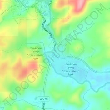
Nombre: Mapa topográfico Nacoochee, altitud, relieve.

Lugar: Nacoochee, White County, Georgia, 30545, United States (34.67510 -83.72046 34.69510 -83.70046)

Altitud media: 449 m

Altitud mínima: 404 m

Altitud máxima: 537 m

Otros mapas topográficos

Haga clic en un mapa para ver su topografía, su altitud y su relieve.

Helen

United States > Georgia > White County

Helen, White County, Georgia, 30545, United States

Altitud media: 488 m

Unicoi Lake

United States > Georgia > White County

Unicoi Lake, White County, Georgia, United States

Altitud media: 562 m

Raven Cliff Falls

United States > Georgia > White County

Raven Cliff Falls, White County, Georgia, United States

Altitud media: 922 m

Cleveland

United States > Georgia > White County

Cleveland, White County, Georgia, 30528, United States

Altitud media: 479 m

Mossy Creek

United States > Georgia > White County

Mossy Creek, White County, Georgia, United States

Altitud media: 416 m

Sautee

United States > Georgia > White County

Sautee, White County, Georgia, 30571, United States

Altitud media: 441 m

Yonah Mountain

United States > Georgia > White County

Yonah Mountain, White County, Georgia, United States

Altitud media: 619 m

Smithgall Woods State Park

United States > Georgia > White County

Smithgall Woods State Park, White County, Georgia, United States

Altitud media: 612 m