
Mapa topográfico Eisenerz
Mapa interactivo
Haga clic en el mapa para ver la altitud.
Eisenerz
A few miles northwest of Eisenerz stands Leopoldstein Castle, and near it Leopoldstein Lake. This lake, with its dark green water at an elevation of 2,028 feet (618 m), and surrounded on all sides by high peaks, is not large and has a depth of 100 ft (30 m).
Acerca de este mapa
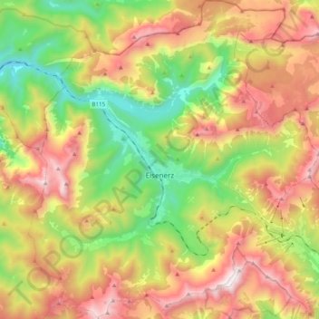
Nombre: Mapa topográfico Eisenerz, altitud, relieve.
Lugar: Eisenerz, Bezirk Leoben, Styria, 8790, Austria (47.48237 14.80499 47.61450 14.98340)
Altitud media: 1.283 m
Altitud mínima: 555 m
Altitud máxima: 2.139 m
Otros mapas topográficos
Haga clic en un mapa para ver su topografía, su altitud y su relieve.