
Mapa topográfico Athens
Mapa interactivo
Haga clic en el mapa para ver la altitud.
Acerca de este mapa
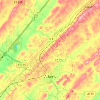
Nombre: Mapa topográfico Athens, altitud, relieve.
Lugar: Athens, McMinn County, Tennessee, United States (35.41927 -84.65609 35.52008 -84.56058)
Altitud media: 291 m
Altitud mínima: 196 m
Altitud máxima: 372 m
The Cherokee were living in McMinn County at the time of the arrival of the first Euro-American explorers. The Athens area was situated nearly halfway between the Overhill Cherokee villages of Great Tellico to the north in Monroe County and Great Hiwassee along the Hiwassee River to the south. In 1819, the Cherokee signed the Calhoun Treaty, selling the land north of the Hiwassee (including all of modern McMinn County) to the United States. McMinn County was organized on November 13, 1819, at the home of John Walker in what is now Calhoun. The Native American village, Pumpkintown (a corruption of Potemkin town), was located on a farm about two miles east of present-day Athens. It is sometimes incorrectly identified as a forerunner of Athens. Athens was laid out and chosen as the county seat in 1822. The name "Athens" may have been chosen due to perceived topographical similarities to Athens, Greece.
Otros mapas topográficos
Haga clic en un mapa para ver su topografía, su altitud y su relieve.
Prof Park
United States > Tennessee > McMinn County > Athens
Prof Park, Athens, McMinn County, East Tennessee, Tennessee, 37371, United States
Altitud media: 292 m
Niota
United States > Tennessee > McMinn County
Niota, McMinn County, Tennessee, 37926, United States
Altitud media: 315 m
Athens
United States > Tennessee > McMinn County > Athens
Athens, McMinn County, Tennessee, 37371, United States
Altitud media: 287 m
Etowah
United States > Tennessee > McMinn County > Etowah
Etowah, McMinn County, Tennessee, 37331, United States
Altitud media: 275 m
Calhoun
United States > Tennessee > McMinn County
Calhoun, McMinn County, East Tennessee, Tennessee, United States
Altitud media: 231 m