
Gracias por apoyar a este sitio ❤️
Haz una donación
Haz una donación
Mapa topográfico Chandalar Shelf
Haga clic en el mapa para ver la altitud.
Gracias por apoyar a este sitio ❤️
Haz una donación
Haz una donación
Acerca de este mapa
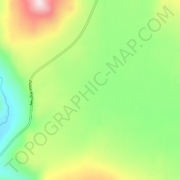
Nombre: Mapa topográfico Chandalar Shelf, altitud, relieve.
Lugar: Chandalar Shelf, North Slope, Alaska, United States (68.04606 -149.60866 68.04616 -149.60856)
Altitud media: 974 m
Altitud mínima: 791 m
Altitud máxima: 1.280 m
Gracias por apoyar a este sitio ❤️
Haz una donación
Haz una donación
Otros mapas topográficos
Haga clic en un mapa para ver su topografía, su altitud y su relieve.
Anaktuvuk Pass
United States > Alaska > North Slope
Anaktuvuk Pass is slightly north of the Brooks Range on the divide between the Anaktuvuk River and the John River, at an elevation of 2,200 ft (670 m). Anaktuvuk Pass is the last remaining settlement of the Nunamiut (People of the Land) Iñupiat Inuit in Alaska.
Altitud media: 727 m
Gracias por apoyar a este sitio ❤️
Haz una donación
Haz una donación