
Mapa topográfico Worthington
Mapa interactivo
Haga clic en el mapa para ver la altitud.
Acerca de este mapa
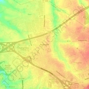
Nombre: Mapa topográfico Worthington, altitud, relieve.
Altitud media: 208 m
Altitud mínima: 161 m
Altitud máxima: 235 m
Otros mapas topográficos
Haga clic en un mapa para ver su topografía, su altitud y su relieve.
Louisville
United States > Kentucky > Jefferson County > Louisville
Louisville, Jefferson County, Kentucky, 40202-2923, United States
Altitud media: 180 m
E.P. "Tom" Sawyer State Park
United States > Kentucky > Jefferson County > Louisville > Lakeland
E.P. "Tom" Sawyer State Park, Lakeland, Louisville, Jefferson County, Kentucky, United States
Altitud media: 209 m
Turkey Run
United States > Kentucky > Jefferson County > Louisville
Turkey Run, Louisville, Jefferson County, Kentucky, United States
Altitud media: 178 m
Riverside Gardens
United States > Kentucky > Jefferson County > Louisville
Riverside Gardens, Louisville, Jefferson County, Kentucky, 40216, United States
Altitud media: 136 m
Saint Dennis
United States > Kentucky > Jefferson County > Louisville
Saint Dennis, Louisville, Jefferson County, Kentucky, 40216, United States
Altitud media: 138 m