
Mapa topográfico Crna Glava
Mapa interactivo
Haga clic en el mapa para ver la altitud.
Acerca de este mapa
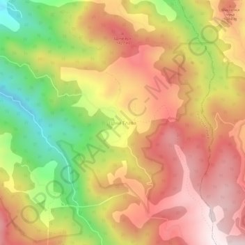
Nombre: Mapa topográfico Crna Glava, altitud, relieve.
Altitud media: 1.235 m
Altitud mínima: 830 m
Altitud máxima: 1.545 m
The village is on the Kopaonik mountain range whose average elevation is 1,397 m (4,583 ft). The highest part of the village is Gobelja hill, easily identifiable from Kopaonik by its antenna. It is said that the village has the purest nature in Serbia, boasting clear waters and rare species of birds and plants. It is a fantastic place for summer mountain adventures such as paragliding, mountain horse riding, and walking. The village has tombs named "stećak" which were made in the middle age. The people living in the village are direct ancestors of Middle Age noble families that were in service to the Nemanjić dynasty royal family and represent a community known as Rascians. The true history of this place was under Ottoman Empire, but there has been no influence on people who live in this village. In the village, you can experience the real spirit of life in Serbia as traditional ways of life have been maintained to the present time.
Otros mapas topográficos
Haga clic en un mapa para ver su topografía, su altitud y su relieve.
Krusevica
Serbia > Central Serbia > Raska Administrative District > Raska Municipality
Krusevica, Raska Municipality, Raska Administrative District, Central Serbia, 36222, Serbia
Altitud media: 809 m
Raška
Serbia > Central Serbia > Raska Administrative District > Raska Municipality
Raška, Raska Municipality, Raska Administrative District, Central Serbia, 36350, Serbia
Altitud media: 550 m