
Mapa topográfico Tallahassee
Mapa interactivo
Haga clic en el mapa para ver la altitud.
Acerca de este mapa
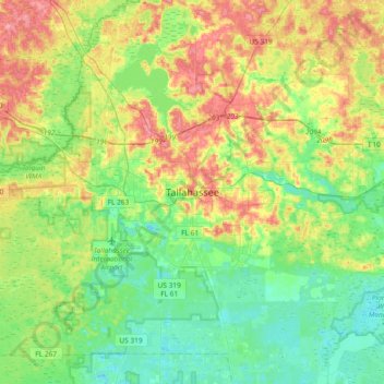
Nombre: Mapa topográfico Tallahassee, altitud, relieve.
Lugar: Tallahassee, Leon County, Florida, 32399-1300, United States (30.27808 -84.44093 30.59808 -84.12093)
Altitud media: 32 m
Altitud mínima: 2 m
Altitud máxima: 83 m
Tallahassee's terrain is hilly by Florida standards, being at the southern end of the Red Hills Region, just above the Cody Scarp. The elevation varies from near sea level to just over 200 feet (61 m), with the state capitol on one of the highest hills in the city. The city includes two large lake basins, Lake Jackson and Lake Lafayette, and borders the northern end of the Apalachicola National Forest.
Otros mapas topográficos
Haga clic en un mapa para ver su topografía, su altitud y su relieve.
Saint Peter
United States > Florida > Leon County > Tallahassee
Saint Peter, Tallahassee, Leon County, Florida, 32308, United States
Altitud media: 49 m
Cascades Park
United States > Florida > Leon County > Tallahassee
Cascades Park, Tallahassee, Leon County, Florida, 32301, United States
Altitud media: 49 m
Four Points
United States > Florida > Leon County > Tallahassee
Four Points, Tallahassee, Leon County, Florida, 32313, United States
Altitud media: 24 m
Henrietta
United States > Florida > Leon County > Tallahassee > Henrietta
Henrietta, Tallahassee, Leon County, Florida, 32313, United States
Altitud media: 20 m