Geolocalizar

Mapa topográfico Lympne

Mapa interactivo

Haga clic en el mapa para ver la altitud.

Acerca de este mapa

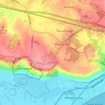
Nombre: Mapa topográfico Lympne, altitud, relieve.

Lugar: Lympne, Folkestone and Hythe District, Kent, England, United Kingdom (51.06661 0.96654 51.09453 1.04742)

Altitud media: 56 m

Altitud mínima: -2 m

Altitud máxima: 113 m

Otros mapas topográficos

Haga clic en un mapa para ver su topografía, su altitud y su relieve.

Hythe

United Kingdom > England > Kent > Folkestone and Hythe District

Hythe, Folkestone and Hythe District, Kent, England, United Kingdom

Altitud media: 32 m

Folkestone

United Kingdom > England > Kent > Folkestone and Hythe District

Folkestone, Folkestone and Hythe District, Kent, England, United Kingdom

Altitud media: 62 m

Park Gate

United Kingdom > England > Kent > Folkestone and Hythe District > Elham

Park Gate, Elham, Folkestone and Hythe District, Kent, England, CT4 6BH, United Kingdom

Altitud media: 130 m

Littlestone on Sea

United Kingdom > England > Kent > Folkestone and Hythe District > New Romney

Littlestone on Sea, New Romney, Folkestone and Hythe District, Kent, England, TN28 8QU, United Kingdom

Altitud media: 1 m

Densole

United Kingdom > England > Kent > Folkestone and Hythe District

Densole, Folkestone and Hythe District, Kent, England, CT18 7BE, United Kingdom

Altitud media: 146 m