
Mapa topográfico Contagem
Mapa interactivo
Haga clic en el mapa para ver la altitud.
Contagem
The city belongs to the metropolitan mesoregion and to the microregion of Belo Horizonte, has a territorial extension of 195.2 square kilometres (75.4 square miles), and borders the municipalities of Ribeirão das Neves, Esmeraldas, Betim, Ibirité and Belo Horizonte. The elevation of the city hall is 939 metres (3,081 feet).
Acerca de este mapa
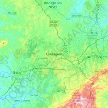
Nombre: Mapa topográfico Contagem, altitud, relieve.
Altitud media: 890 m
Altitud mínima: 711 m
Altitud máxima: 1.508 m
Otros mapas topográficos
Haga clic en un mapa para ver su topografía, su altitud y su relieve.
Nova Contagem
Brazil > Minas Gerais > Região Metropolitana de Belo Horizonte > Contagem
Altitud media: 907 m
Vila Beneves
Brazil > Minas Gerais > Região Metropolitana de Belo Horizonte > Contagem
Altitud media: 897 m