
Mapa topográfico Rajah Sikatuna Protected Landscape
Mapa interactivo
Haga clic en el mapa para ver la altitud.
Acerca de este mapa
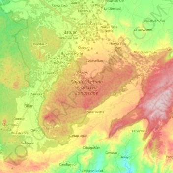
Nombre: Mapa topográfico Rajah Sikatuna Protected Landscape, altitud, relieve.
Altitud media: 349 m
Altitud mínima: 27 m
Altitud máxima: 715 m
The Rajah Sikatuna park occupies the low mountain range in the south of Bohol island which corresponds geographically with the municipalities of Carmen, Sierra Bullones, Garcia Hernandez, Valencia, Dimiao, Bilar , Loboc and Batuan. It is characterized by rolling hills with remnants of natural forest on steep limestone terrain surrounded by plantation forest, denuded hills and grasslands. The park has an average elevation of 400 metres (1,300 ft) and is composed of 60% limestone forest, 15% grassland, 5% plantations, and 10% permanent agricultural areas. It also contains the Bilar Peak, one of the highest in the province at 1,673 feet (510 m) above sea level, as well as 4 mountain springs that supply water to the surrounding communities namely, the Logarita, Anislag, Mabugnao and Aghuban springs.