Geolocalizar

Mapa topográfico Lutter

Haga clic en el mapa para ver la altitud.

Acerca de este mapa

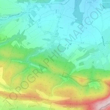
Nombre: Mapa topográfico Lutter, altitud, relieve.

Lugar: Lutter, Altkirch, Haut-Rhin, Grand Est, Metropolitan France, 68480, France (47.44283 7.33816 47.47599 7.39732)

Altitud media: 516 m

Altitud mínima: 407 m

Altitud máxima: 770 m

Otros mapas topográficos

Haga clic en un mapa para ver su topografía, su altitud y su relieve.

Ballon d'Alsace

France > Grand Est > Haut-Rhin > Sewen

Altitud media: 994 m

Schorren

France > Grand Est > Haut-Rhin > Hohrod

Altitud media: 665 m

Col du Platzerwasel

France > Grand Est > Haut-Rhin > Mittlach

The Col du Platzerwasel (elevation 1,182 m (3,878 ft)) is a mountain pass situated in the Vosges Mountains in the Haut-Rhin department of France, between Sondernach and Le Markstein. It has been crossed occasionally during the Tour de France cycle race, including on Stage 10 of the 2014 race.

Altitud media: 1.024 m

Bingle

France > Grand Est > Haut-Rhin > Eschentzwiller

Altitud media: 274 m

Hohneck

France > Grand Est > Haut-Rhin > Stosswihr

Altitud media: 1.136 m

Le Solberg

France > Grand Est > Haut-Rhin > Eschbach-au-Val

Altitud media: 620 m

Wang

France > Grand Est > Haut-Rhin > Hohrod

Altitud media: 567 m

Steinmattenmuehle

France > Grand Est > Haut-Rhin > Leymen

Altitud media: 417 m

Pairis

France > Grand Est > Haut-Rhin > Orbey

Altitud media: 801 m

Lac Blanc

France > Grand Est > Haut-Rhin > Orbey

Lac Blanc is a lake in Haut-Rhin, France. At an elevation of 1055 m, its surface area is 0.29 km².

Altitud media: 1.111 m

Kutz

France > Grand Est > Haut-Rhin > Katzenthal

Altitud media: 351 m

Hohrodberg

France > Grand Est > Haut-Rhin > Hohrod

Altitud media: 696 m

Wanne

France > Grand Est > Haut-Rhin > Dietwiller

Altitud media: 282 m

Le Markstein

France > Grand Est > Haut-Rhin > Fellering

Le Markstein is a winter sports station in the Vosges mountains in France situated at an altitude of between 1,020 m (3,346 ft) and 1,268 m (4,160 ft) which is located on the Route des Crêtes. It forms a set of cross-country skiing with the Breitfirst ski-station and the Grand Ballon. The highest point is the…

Altitud media: 1.013 m

Lac Noir

France > Grand Est > Haut-Rhin > Orbey

Lac Noir is a lake in Orbey, Alsace, France. At an elevation of 955 m, its surface area is 0.14 km².

Altitud media: 1.052 m

Steye

France > Grand Est > Haut-Rhin > Kirchberg > Steye

Altitud media: 597 m

Rueti

France > Grand Est > Haut-Rhin > Schlierbach

Altitud media: 260 m

Hassal

France > Grand Est > Haut-Rhin > Courtavon

Altitud media: 499 m