
Mapa topográfico West Virginia
Mapa interactivo
Haga clic en el mapa para ver la altitud.
Acerca de este mapa
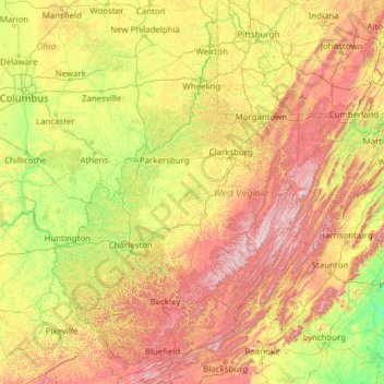
Nombre: Mapa topográfico West Virginia, altitud, relieve.
Lugar: West Virginia, United States of America (37.20148 -82.64474 40.63880 -77.71903)
Altitud media: 430 m
Altitud mínima: 84 m
Altitud máxima: 1.452 m
West Virginia is located entirely within the Appalachian Region, and the state is almost entirely mountainous, giving reason to the nickname The Mountain State and the motto Montani Semper Liberi ("Mountaineers are always free"). The elevations and ruggedness drop near large rivers like the Ohio River or Shenandoah River. About 75% of the state is within the Cumberland Plateau and Allegheny Plateau regions. Though the relief is not high, the plateau region is extremely rugged in most areas. The average elevation of West Virginia is approximately 1,500 feet (460 m) above sea level, which is the highest of any U.S. state east of the Mississippi River.