
Gracias por apoyar a este sitio ❤️
Haz una donación
Haz una donación
Mapa topográfico Porto da Cruz
Haga clic en el mapa para ver la altitud.
Gracias por apoyar a este sitio ❤️
Haz una donación
Haz una donación
Porto da Cruz
The northern parish is enveloped by the mountains of Paul da Serra: Pico da Suna (1040 metres), Pico do Larano (765 metres) and Pico da Maiata (766 metres) are the highest points in the parish. Even along the coast, Penha de Águia (a mountainous escarpment 580 metres in altitude) is difficult to climb; the area, Penha da Águia, means mountain of the eagles, giving the impression that only the birds settle these lands.
Gracias por apoyar a este sitio ❤️
Haz una donación
Haz una donación
Acerca de este mapa
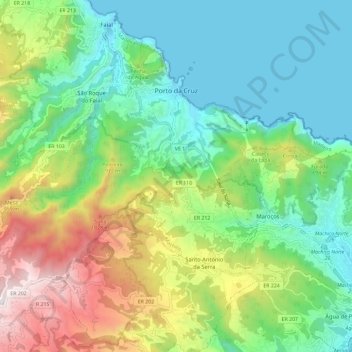
Nombre: Mapa topográfico Porto da Cruz, altitud, relieve.
Lugar: Porto da Cruz, Machico, Madeira, Portugal (32.70993 -16.90556 32.78754 -16.78922)
Altitud media: 448 m
Altitud mínima: -2 m
Altitud máxima: 1.409 m
Gracias por apoyar a este sitio ❤️
Haz una donación
Haz una donación
Otros mapas topográficos
Haga clic en un mapa para ver su topografía, su altitud y su relieve.