
Haz una donación
Mapa topográfico Diamond Springs
Haga clic en el mapa para ver la altitud.
Haz una donación
Diamond Springs
Diamond Springs (formerly, Diamond Spring and Diamond) is a census-designated place (CDP) in El Dorado County, California, United States. It is part of the Sacramento–Arden-Arcade–Roseville Metropolitan Statistical Area. The population was 11,037 at the 2010 census, up from 4,888 at the 2000 census. The town is registered as California Historical Landmark number 487. It lies at an elevation of 1791 feet (546 m).
Haz una donación
Acerca de este mapa
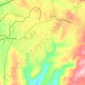
Nombre: Mapa topográfico Diamond Springs, altitud, relieve.
Altitud media: 531 m
Altitud mínima: 349 m
Altitud máxima: 711 m
Haz una donación
Otros mapas topográficos
Haga clic en un mapa para ver su topografía, su altitud y su relieve.
Haz una donación
Diamond Springs
United States > California > El Dorado County
Diamond Springs (formerly, Diamond Spring and Diamond) is a census-designated place (CDP) in El Dorado County, California, United States. It is part of the Sacramento–Arden-Arcade–Roseville Metropolitan Statistical Area. The population was 11,037 at the 2010 census, up from 4,888 at the 2000 census. The…
Altitud media: 531 m
Haz una donación
El Dorado
United States > California > El Dorado County
El Dorado (Spanish for "The Golden") is an unincorporated community in El Dorado County, California. It is located 4 miles (6.4 km) southwest of Placerville, at an elevation of 1608 feet (490 m). The population was 4,096 at the 2000 census. The town is registered as California Historical Landmark #486. The ZIP…
Altitud media: 511 m
Cameron Park
United States > California > El Dorado County
Cameron Park is situated in an interior chaparral zone or brush zone just east of the Central Valley. It is the closest population center to the Pine Hill Ecological Reserve. Native vegetation includes an abundance of redbud and manzanita bushes, and brush in general. Where treed the native trees are primarily…
Altitud media: 390 m
Lake Tahoe Basin Management Unit
United States > California > El Dorado County
The Lake Tahoe Basin Management Unit is a United States National Forest that manages and protects public land surrounding Lake Tahoe and the Lake Tahoe Basin. Straddling the state borders of California and Nevada in the Sierra Nevada, the LTBMU encompasses 154,851 acres (626 km²) of National Forest system…
Altitud media: 1.981 m
Haz una donación
Eldorado National Forest
United States > California > El Dorado County
The forest ranges in elevation from 1,000 feet (300 m) in the foothills to more than 10,000 feet (3,000 m) above sea level along the Sierra crest. The mountainous topography is broken by the steep canyons of the Mokelumne, Cosumnes, American, and Rubicon rivers. Plateaus of generally moderate relief are…
Altitud media: 1.807 m
Pollock Pines
United States > California > El Dorado County
Pollock Pines is a census-designated place (CDP) in El Dorado County, California, United States. It is part of the Sacramento–Arden-Arcade–Roseville Metropolitan Statistical Area. Pollock Pines lies at an elevation of 3,980 feet (1,210 m) in the Sierra Nevada. The population was 6,871 at the 2010 census,…
Altitud media: 1.122 m
Haz una donación
South Lake Tahoe
United States > California > El Dorado County > South Lake Tahoe > South Lake Tahoe
Altitud media: 1.944 m
Haz una donación
Kingsville
United States > California > El Dorado County
Kingsville (formerly, Kingville) is an unincorporated community in El Dorado County, California. It is located 5 miles (8 km) southwest of Placerville, at an elevation of 1532 feet (467 m).
Altitud media: 473 m
Cameron Airpark Estates
United States > California > El Dorado County > Cameron Park
Altitud media: 411 m
Haz una donación
Tallac Village
United States > California > El Dorado County > South Lake Tahoe
Altitud media: 1.945 m
Haz una donación
Haz una donación
Echo Summit
United States > California > El Dorado County
Echo Summit is notable for being the location (sometimes listed as "South Lake Tahoe") of the 1968 U.S. Olympic track and field trials for men, held September 6–16, a month before the 1968 Olympics in Mexico City. (The women's trials were at low altitude in Los Angeles County, at Walnut.) The Echo Summit…
Altitud media: 2.200 m
Haz una donación
Haz una donación