Geolocalizar

Mapa topográfico Richborough

Mapa interactivo

Haga clic en el mapa para ver la altitud.

Acerca de este mapa

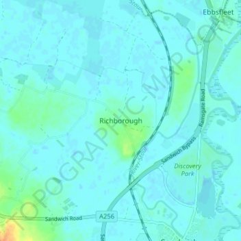
Nombre: Mapa topográfico Richborough, altitud, relieve.

Lugar: Richborough, Dover, Kent, England, CT13 9JH, United Kingdom (51.27547 1.30524 51.31547 1.34524)

Altitud media: 4 m

Altitud mínima: -1 m

Altitud máxima: 31 m

Otros mapas topográficos

Haga clic en un mapa para ver su topografía, su altitud y su relieve.

White Cliffs of Dover

United Kingdom > England > Kent > Dover > St. Margaret's at Cliffe

White Cliffs of Dover, St. Margaret's at Cliffe, Dover, Kent, England, United Kingdom

Altitud media: 49 m

Elmstone

United Kingdom > England > Kent > Dover > Preston

Elmstone, Preston, Dover, Kent, England, CT3 1HE, United Kingdom

Altitud media: 13 m

Sandwich Bay

United Kingdom > England > Kent > Dover

Sandwich Bay, Dover, Kent, England, CT13 9PZ, United Kingdom

Altitud media: 1 m

Claypits

United Kingdom > England > Kent > Dover > Goodnestone

Claypits, Goodnestone, Dover, Kent, England, CT3 1PB, United Kingdom

Altitud media: 34 m

River

United Kingdom > England > Kent > Dover

River, Dover, Kent, England, United Kingdom

Altitud media: 80 m

St. Margaret's at Cliffe

United Kingdom > England > Kent > Dover

St. Margaret's at Cliffe, Dover, Kent, England, United Kingdom

Altitud media: 53 m