
Mapa topográfico Town of Guilderland
Mapa interactivo
Haga clic en el mapa para ver la altitud.
Acerca de este mapa
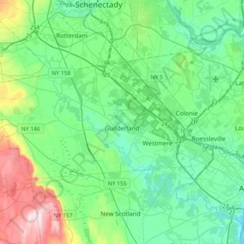
Nombre: Mapa topográfico Town of Guilderland, altitud, relieve.
Lugar: Town of Guilderland, Albany County, New York, United States (42.65915 -74.10672 42.76064 -73.81251)
Altitud media: 126 m
Altitud mínima: 2 m
Altitud máxima: 551 m
Otros mapas topográficos
Haga clic en un mapa para ver su topografía, su altitud y su relieve.
Alcove
United States > New York > Albany County > Town of Coeymans
Alcove, Town of Coeymans, Albany County, New York, 12007, United States
Altitud media: 209 m
City of Watervliet
United States > New York > Albany County
City of Watervliet, Albany County, New York, 12189, United States
Altitud media: 25 m
Karlsfeld
United States > New York > Albany County > City of Albany
Karlsfeld, City of Albany, Albany County, New York, 12159, United States
Altitud media: 57 m
City of Albany
United States > New York > Albany County
City of Albany, Albany County, New York, United States
Altitud media: 68 m