
Mapa topográfico Peine
Mapa interactivo
Haga clic en el mapa para ver la altitud.
Acerca de este mapa
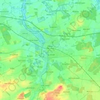
Nombre: Mapa topográfico Peine, altitud, relieve.
Lugar: Peine, Landkreis Peine, Lower Saxony, Germany (52.25810 10.11768 52.37449 10.34838)
Altitud media: 74 m
Altitud mínima: 58 m
Altitud máxima: 111 m
Otros mapas topográficos
Haga clic en un mapa para ver su topografía, su altitud y su relieve.
Hohenhameln
Germany > Lower Saxony > Landkreis Peine
Hohenhameln, Landkreis Peine, Lower Saxony, 31249, Germany
Altitud media: 77 m
Lengede
Germany > Lower Saxony > Landkreis Peine
Lengede, Landkreis Peine, Lower Saxony, 38268, Germany
Altitud media: 87 m