
Mapa topográfico Franklin
Mapa interactivo
Haga clic en el mapa para ver la altitud.
Franklin
According to the United States Census Bureau, the city has a total area of 29.2 square miles (75.5 km2), of which 27.5 square miles (71.1 km2) are land and 1.7 square miles (4.5 km2) are water, comprising 5.95% of the town. It is drained by the Winnipesaukee, Pemigewasset and Merrimack rivers. Webster Lake is in the north. The highest point in Franklin is an unnamed summit near the northwestern corner of the city limits, where the elevation reaches approximately 1,370 feet (420 m) above sea level. Franklin lies fully within the Merrimack River watershed.
Acerca de este mapa
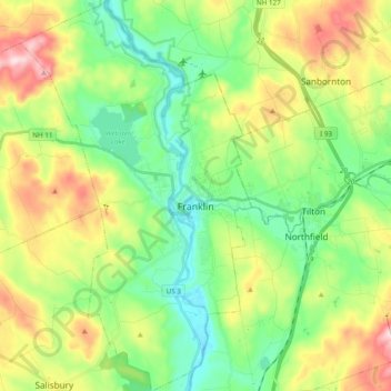
Nombre: Mapa topográfico Franklin, altitud, relieve.
Altitud media: 201 m
Altitud mínima: 76 m
Altitud máxima: 431 m
Otros mapas topográficos
Haga clic en un mapa para ver su topografía, su altitud y su relieve.
Rings Corner
United States > New Hampshire > Merrimack County > Pittsfield > Rings Corner
Altitud media: 190 m