
Mapa topográfico Pung-ol Peak
Mapa interactivo
Haga clic en el mapa para ver la altitud.
Acerca de este mapa
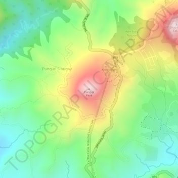
Nombre: Mapa topográfico Pung-ol Peak, altitud, relieve.
Lugar: Pung-ol Peak, Cebu City, Central Visayas, Philippines (10.39383 123.85445 10.39393 123.85455)
Altitud media: 496 m
Altitud mínima: 330 m
Altitud máxima: 726 m
Otros mapas topográficos
Haga clic en un mapa para ver su topografía, su altitud y su relieve.
Pamutan Grassland
Philippines > Cebu City > Pamutan > Mahayahay
Pamutan Grassland, Mahayahay, Pamutan, Cebu City, Central Visayas, Philippines
Altitud media: 374 m
Sirao Peak
Sirao Peak, Cebu City, Central Visayas, Philippines
Altitud media: 493 m
Bocawe
Philippines > Cebu City > Bocawe
Bocawe, Cebu City, Central Visayas, Philippines
Altitud media: 407 m
Bulacao Pardo
Philippines > Cebu City > Bulacao Pardo
Bulacao Pardo, Cebu City, Central Visayas, 6045, Philippines
Altitud media: 69 m
Mountain View
Philippines > Cebu City > Malubog > Tiguib
Mountain View, Cebu Tops Road, Tiguib, Malubog, Cebu City, Central Visayas, Philippines
Altitud media: 420 m
Banilad Streetscape
Banilad Streetscape, Cebu City, Central Visayas, 6666, Philippines
Altitud media: 68 m
Piazza Elesia
Philippines > Cebu City > Piazza Elesia
Piazza Elesia, Cebu City, Central Visayas, 653, Philippines
Altitud media: 69 m