
Haz una donación
Mapa topográfico Vyas (Damauli)
Haga clic en el mapa para ver la altitud.
Haz una donación
Acerca de este mapa
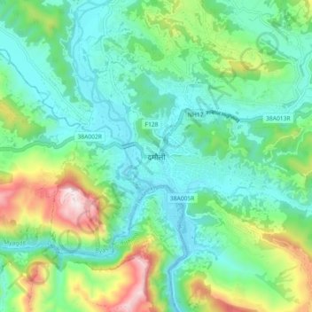
Nombre: Mapa topográfico Vyas (Damauli), altitud, relieve.
Lugar: Vyas (Damauli), Byas, Tanahun, Gandaki Province, Nepal (27.93706 84.22862 28.01706 84.30862)
Altitud media: 501 m
Altitud mínima: 294 m
Altitud máxima: 1.079 m
Haz una donación
Otros mapas topográficos
Haga clic en un mapa para ver su topografía, su altitud y su relieve.
Bandipur
Nepal > Gandaki Province > Tanahun
Bandipur is located at 27.56 N, 84.25 E and an elevation of 1030m on a mountain saddle (Mahabharat range) approximately 700m above the Marsyangdi River Valley, 143 km to the west of Kathmandu and 80 km to the east of Pokhara. Since 1998 it is connected by an 8 km access road from Dumre (Prithvi Highway). Until…
Altitud media: 719 m
Haz una donación
Bandipur
Nepal > Gandaki Province > Tanahun
Bandipur is located at 27.56 N, 84.25 E and an elevation of 1030m on a mountain saddle (Mahabharat range) approximately 700m above the Marsyangdi River Valley, 143 km to the west of Kathmandu and 80 km to the east of Pokhara. Since 1998 it is connected by an 8 km access road from Dumre (Prithvi Highway). Until…
Altitud media: 719 m