
Haz una donación
Mapa topográfico Harsil
Haga clic en el mapa para ver la altitud.
Haz una donación
Acerca de este mapa
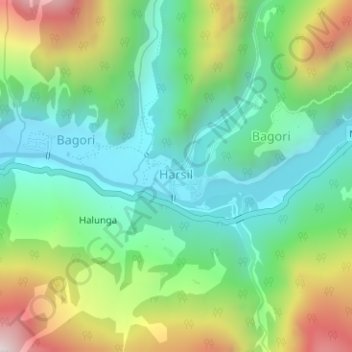
Nombre: Mapa topográfico Harsil, altitud, relieve.
Lugar: Harsil, Bhatwari, Uttarkashi, Uttarakhand, India (31.03390 78.74709 31.03965 78.75525)
Altitud media: 2.761 m
Altitud mínima: 2.464 m
Altitud máxima: 3.350 m
Haz una donación
Otros mapas topográficos
Haga clic en un mapa para ver su topografía, su altitud y su relieve.
Uttarkashi
India > Uttarakhand > Bhatwari
It is the district headquarters of Uttarkashi district. Uttarkashi is situated on the banks of river Bhagirathi at an altitude of 1158 m above sea level. Uttarkashi is generally known as a holy town close to Rishikesh. It is located in the state of Uttarakhand in India. Uttarkashi is home to a number of…
Altitud media: 1.619 m
Haz una donación
Haz una donación
Gomukh, Ice Cave
India > Uttarakhand > Bhatwari
Around the snout, nature presents a wild topography. There are boulders scattered here and there with some pieces of broken snow, along with the hard clayey snow of the glacier.
Altitud media: 4.286 m
Haz una donación
Haz una donación