
Mapa topográfico Mont Vernon
Mapa interactivo
Haga clic en el mapa para ver la altitud.
Mont Vernon
There is a gun sporting range in town (the Purgatory Falls Fish & Game Club), and local hunting can be widely found in the fall. There was a ski hill with a rope tow that disbanded in the middle of the 20th century. Mont Vernon is known for views over the Souhegan Valley and has hiking trails, especially in town-owned Lamson Farm and along Purgatory Brook, which forms most of its western border. The Morrissette Trail, opened in May 2012, goes from the lowest to the highest points in Mont Vernon for an elevation gain of 700 feet (210 m) (315 to 1,015 feet (96 to 309 m)). It is sponsored by Summit for a Cure.
Acerca de este mapa
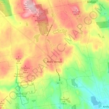
Nombre: Mapa topográfico Mont Vernon, altitud, relieve.
Altitud media: 194 m
Altitud mínima: 69 m
Altitud máxima: 320 m
Otros mapas topográficos
Haga clic en un mapa para ver su topografía, su altitud y su relieve.
South Uncanoonuc Mountain
United States > New Hampshire > Hillsborough County > Goffstown
Altitud media: 243 m
Souhegan River
United States > New Hampshire > Hillsborough County > Milford > East Milford
Altitud media: 84 m
Piscataquog River
United States > New Hampshire > Hillsborough County > Manchester
Altitud media: 59 m
Souhegan River Watershed Dam Number 35
United States > New Hampshire > Hillsborough County > New Ipswich > Smithville
Altitud media: 349 m
West Peterborough
United States > New Hampshire > Hillsborough County > Peterborough
Altitud media: 299 m
Hillsboro Lower Village
United States > New Hampshire > Hillsborough County > Hillsborough
Altitud media: 242 m
Campbell Mountain
United States > New Hampshire > Hillsborough County > Hillsborough
Altitud media: 338 m
Massachusetts Drive Park
United States > New Hampshire > Hillsborough County > Nashua
Altitud media: 48 m
Souhegan River
United States > New Hampshire > Hillsborough County > Milford > East Milford
Altitud media: 84 m
North Brookline
United States > New Hampshire > Hillsborough County > Brookline > North Brookline
Altitud media: 124 m
Nakuru Lake
United States > New Hampshire > Hillsborough County > Hudson > Hudson Center
Altitud media: 80 m
South Weare
United States > New Hampshire > Hillsborough County > Weare > South Weare
Altitud media: 210 m