
Haz una donación
Mapa topográfico Moon Township
Haga clic en el mapa para ver la altitud.
Haz una donación
Moon Township
During the Cold War, Moon Township was the location of Nike Site PI-71, which was a battery of Nike Ajax and/or Nike Hercules surface-to-air missiles, used by US armed forces for high – and medium-altitude air defense. The former missile site is now a nature preserve.
Haz una donación
Acerca de este mapa
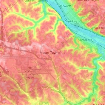
Nombre: Mapa topográfico Moon Township, altitud, relieve.
Lugar: Moon Township, Allegheny County, Pennsylvania, United States (40.45555 -80.27438 40.55643 -80.14113)
Altitud media: 316 m
Altitud mínima: 206 m
Altitud máxima: 389 m
Haz una donación
Otros mapas topográficos
Haga clic en un mapa para ver su topografía, su altitud y su relieve.
Haz una donación
Champion
United States > Pennsylvania > Allegheny County > North Fayette Township
Altitud media: 360 m
Haz una donación
Haz una donación
Coraopolis Heights
United States > Pennsylvania > Allegheny County > Findlay Township
Altitud media: 320 m
Central Highlands
United States > Pennsylvania > Allegheny County > Elizabeth Township
Altitud media: 327 m
Sturgeon
United States > Pennsylvania > Allegheny County > North Fayette Township
Altitud media: 334 m
Haz una donación
Highland Park Reservoir No. 2
United States > Pennsylvania > Allegheny County > Pittsburgh
Altitud media: 275 m
Haz una donación
Haz una donación
Allegheny River Lock and Dam No. 2
United States > Pennsylvania > Allegheny County > O'Hara Township
Altitud media: 268 m
Haz una donación
Haz una donación
Neville Island
United States > Pennsylvania > Allegheny County > Neville Township
Altitud media: 289 m
Coverdale
United States > Pennsylvania > Allegheny County > Bethel Park > Coverdale
Altitud media: 354 m
Haz una donación
Clinton
United States > Pennsylvania > Allegheny County > Findlay Township > Clinton
Altitud media: 350 m
Glenwillard
United States > Pennsylvania > Allegheny County > Crescent Township > Glenwillard
Altitud media: 278 m
Haz una donación