
Haz una donación
Mapa topográfico Gadahinglaj
Haga clic en el mapa para ver la altitud.
Haz una donación
Gadahinglaj
Gadhinglaj is situated on the banks of the Hiranyakeshi river, which originates in the Amboli Ghats mountains. It is located at the border between Maharashtra and Karnataka. Maharashtra State Highway 134 passes through the city. Gadinglaj is the headquarters of South Kolhapur and a sub-district of the Kolhapur District. It is the largest city in South Kolhapur and has enough area and population to be deemed a district. The city is at an average elevation of 623 metres (2,044 ft).
Haz una donación
Acerca de este mapa
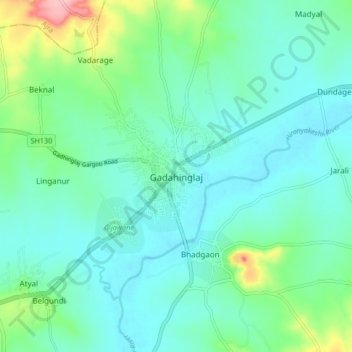
Nombre: Mapa topográfico Gadahinglaj, altitud, relieve.
Lugar: Gadahinglaj, Gadhinglaj, Kolhapur, Maharashtra, 416502, India (16.18369 74.31159 16.26369 74.39159)
Altitud media: 655 m
Altitud mínima: 624 m
Altitud máxima: 773 m
Haz una donación
Otros mapas topográficos
Haga clic en un mapa para ver su topografía, su altitud y su relieve.