
Gracias por apoyar a este sitio ❤️
Haz una donación
Haz una donación
Mapa topográfico Nagarkot
Haga clic en el mapa para ver la altitud.
Gracias por apoyar a este sitio ❤️
Haz una donación
Haz una donación
Nagarkot
At the time of the 2021 census it had a population of 5,234 and had 1,084 houses in it. At an elevation of 2,195 meters, it is considered one of the most scenic spots in Bhaktapur District. Nagarkot also offers views of the Kathmandu Valley. The scenery of the place makes it a popular hiking route for tourists. It is located approximately 7000 ft (2000 m) above sea level and 28 km from Kathmandu International Airport.
Gracias por apoyar a este sitio ❤️
Haz una donación
Haz una donación
Acerca de este mapa
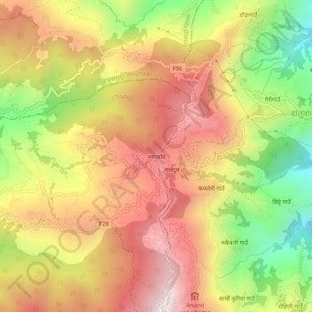
Nombre: Mapa topográfico Nagarkot, altitud, relieve.
Altitud media: 1.679 m
Altitud mínima: 1.214 m
Altitud máxima: 2.059 m
Gracias por apoyar a este sitio ❤️
Haz una donación
Haz una donación
Otros mapas topográficos
Haga clic en un mapa para ver su topografía, su altitud y su relieve.
Gracias por apoyar a este sitio ❤️
Haz una donación
Haz una donación
Gracias por apoyar a este sitio ❤️
Haz una donación
Haz una donación