
Mapa topográfico Sixteen Mile Creek
Mapa interactivo
Haga clic en el mapa para ver la altitud.
Acerca de este mapa
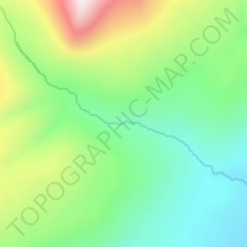
Nombre: Mapa topográfico Sixteen Mile Creek, altitud, relieve.
Altitud media: 1.267 m
Altitud mínima: 1.027 m
Altitud máxima: 1.711 m
Otros mapas topográficos
Haga clic en un mapa para ver su topografía, su altitud y su relieve.
Beaver Lake
Canada > British Columbia > Regional District of Kitimat-Stikine > Area F (Dease Lake) > Dease Lake
Beaver Lake, Dease Lake, Area F (Dease Lake), Regional District of Kitimat-Stikine, British Columbia, Canada
Altitud media: 865 m
Dease Lake
Canada > British Columbia > Regional District of Kitimat-Stikine > Area F (Dease Lake)
Dease Lake, Area F (Dease Lake), Regional District of Kitimat-Stikine, British Columbia, V0C 1L0, Canada
Altitud media: 898 m
Ball Creek
Canada > British Columbia > Regional District of Kitimat-Stikine > Area F (Dease Lake)
Ball Creek, Area F (Dease Lake), Regional District of Kitimat-Stikine, British Columbia, Canada
Altitud media: 1.267 m