
Mapa topográfico Brede
Mapa interactivo
Haga clic en el mapa para ver la altitud.
Acerca de este mapa
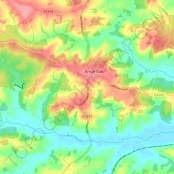
Nombre: Mapa topográfico Brede, altitud, relieve.
Lugar: Brede, Rother District, East Sussex, England, United Kingdom (50.92703 0.55277 50.96314 0.64143)
Altitud media: 40 m
Altitud mínima: 0 m
Altitud máxima: 96 m
Otros mapas topográficos
Haga clic en un mapa para ver su topografía, su altitud y su relieve.
Bewl Water
United Kingdom > England > East Sussex > Rother District > Ticehurst
Bewl Water, Ticehurst, Rother District, East Sussex, South East England, England, United Kingdom
Altitud media: 92 m
Fairlight
United Kingdom > England > East Sussex > Rother District
Fairlight, Rother District, East Sussex, England, United Kingdom
Altitud media: 47 m
Icklesham
United Kingdom > England > East Sussex > Rother District
Icklesham, Rother District, East Sussex, England, United Kingdom
Altitud media: 26 m