
Haz una donación
Mapa topográfico Carnegie
Haga clic en el mapa para ver la altitud.
Haz una donación
Carnegie
According to the United States Census Bureau, the borough has a total area of 1.6 square miles (4.1 km2), all land. Its average elevation is 833 ft (254 m) above sea level.
Haz una donación
Acerca de este mapa
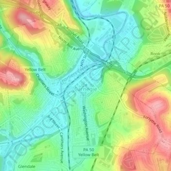
Nombre: Mapa topográfico Carnegie, altitud, relieve.
Lugar: Carnegie, Allegheny County, Pennsylvania, United States (40.39856 -80.09999 40.41997 -80.06742)
Altitud media: 275 m
Altitud mínima: 226 m
Altitud máxima: 350 m
Haz una donación
Otros mapas topográficos
Haga clic en un mapa para ver su topografía, su altitud y su relieve.
Haz una donación
Champion
United States > Pennsylvania > Allegheny County > North Fayette Township
Altitud media: 360 m
Haz una donación
Haz una donación
Coraopolis Heights
United States > Pennsylvania > Allegheny County > Findlay Township
Altitud media: 320 m
Central Highlands
United States > Pennsylvania > Allegheny County > Elizabeth Township
Altitud media: 327 m
Sturgeon
United States > Pennsylvania > Allegheny County > North Fayette Township
Altitud media: 334 m
Haz una donación
Highland Park Reservoir No. 2
United States > Pennsylvania > Allegheny County > Pittsburgh
Altitud media: 275 m
Haz una donación
Haz una donación
Allegheny River Lock and Dam No. 2
United States > Pennsylvania > Allegheny County > O'Hara Township
Altitud media: 268 m
Haz una donación
Haz una donación
Neville Island
United States > Pennsylvania > Allegheny County > Neville Township
Altitud media: 289 m
Coverdale
United States > Pennsylvania > Allegheny County > Bethel Park > Coverdale
Altitud media: 354 m
Haz una donación
Clinton
United States > Pennsylvania > Allegheny County > Findlay Township > Clinton
Altitud media: 350 m
Glenwillard
United States > Pennsylvania > Allegheny County > Crescent Township > Glenwillard
Altitud media: 278 m
Haz una donación