
Mapa topográfico Seville
Haga clic en el mapa para ver la altitud.
Acerca de este mapa
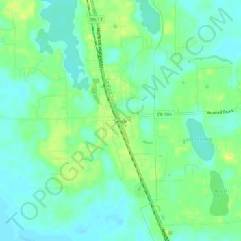
Nombre: Mapa topográfico Seville, altitud, relieve.
Lugar: Seville, Volusia County, Florida, 32190, United States (29.29692 -81.51257 29.33692 -81.47257)
Altitud media: 13 m
Altitud mínima: 4 m
Altitud máxima: 28 m
Otros mapas topográficos
Haga clic en un mapa para ver su topografía, su altitud y su relieve.
DeLand
United States > Florida > Volusia County
DeLand features a varied topography characterized primarily by gentle slopes and a mix of wetlands and uplands. The city covers approximately 17.8 square miles, with about 17.6 square miles of land and a small percentage dedicated to water bodies. The elevation in DeLand is relatively modest, typically ranging…
Altitud media: 20 m
Deltona
United States > Florida > Volusia County
The majority of the land in the city is of karst topography, characterized by rolling hills and an abundant amount of lakes. The St. Johns River passes through Lake Monroe, directly south of the city. The United States Geological Survey lists the city's elevation at 33 feet (10 m) above sea level at a point…
Altitud media: 12 m
Samsula-Spruce Creek
United States > Florida > Volusia County > New Smyrna Beach > South Village
Altitud media: 8 m
South Daytona
United States > Florida > Volusia County
According to the United States Census Bureau, the city has a total area of 5.0 square miles (13.0 km2), of which 3.7 square miles (9.6 km2) is land and 1.3 square miles (3.4 km2) (26.29%) is water. There are nearly 44.5 miles (71.6 km) of roadway, 40 miles (64 km) of sewer lines, and 55 miles (89 km) of water…
Altitud media: 4 m
Deltona
United States > Florida > Volusia County
The majority of the land in the city is of karst topography, characterized by rolling hills and an abundant amount of lakes. The St. Johns River passes through Lake Monroe, directly south of the city. The United States Geological Survey lists the city's elevation at 33 feet (10 m) above sea level at a point…
Altitud media: 12 m