
Haz una donación
Mapa topográfico Woodberry
Haga clic en el mapa para ver la altitud.
Haz una donación
Woodberry
Woodberry also houses the facilities for four of Baltimore's commercial television stations, and because of its altitude, it also is the site of two large broadcasting masts. This area, once known as Malden Hill, is also known as Television Hill (or simply TV Hill). The first television station and transmission tower were completed in 1948.
Haz una donación
Acerca de este mapa
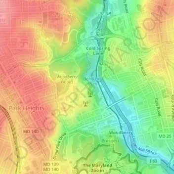
Nombre: Mapa topográfico Woodberry, altitud, relieve.
Lugar: Woodberry, Park Heights, Baltimore, Maryland, United States (39.32956 -76.65820 39.34524 -76.64207)
Altitud media: 94 m
Altitud mínima: 40 m
Altitud máxima: 141 m
Haz una donación
Otros mapas topográficos
Haga clic en un mapa para ver su topografía, su altitud y su relieve.
Baltimore
United States > Maryland > Baltimore
Baltimore is in north-central Maryland on the Patapsco River close to where it empties into the Chesapeake Bay. The city is also located on the fall line between the Piedmont Plateau and the Atlantic coastal plain, which divides Baltimore into "lower city" and "upper city". The city's elevation ranges from sea…
Altitud media: 65 m
Haz una donación
Station North Arts and Entertainment District
United States > Maryland > Baltimore
Altitud media: 40 m